
OREGON RANGELAND
MONITORING PROGRAM
The Oregon Rangeland Monitoring Program (ORMP) is a collaborative effort involving multiple stakeholders to measure and communicate the effectiveness of rangeland restoration treatments in eastern Oregon.
There are millions of dollars being invested in landscape restoration treatments in response to wildfires and wildlife habitat improvement projects. These projects are often multi-phase, and extend across large landscapes. This offers a unique opportunity to measure restoration outcomes across larger spatial and temporal scales than previously possible, which can significantly enhance our collective impact.
To make the most of this opportunity, we need an efficient method to assess whether our collective efforts are increasing the quality and quantity of sagebrush habitat in Oregon, and we need to communicate these results to funders and decision-makers, as well as share lessons among practitioners.
Who uses ORMP?
Baker LIT
BLM
Department of State Lands
High Desert Partnership
Institute for Natural Resources
ODFW
We leverage the knowledge of our diverse stakeholder group to synthesize monitoring data, helping bridge the knowledge gap between small-scale experiments and real-world, landscape-scale management. Our approach is designed not only to determine if treatments succeed or fail, but also to identify factors that contributed to treatment outcomes.
Guidance on where and how many locations to monitor
US Geological Survey (USGS) helps practitioners identify a sufficient number of monitoring sites within restoration treatment boundaries and control (reference) areas to efficiently capture information across ecologically diverse areas.
Electronic data collection (using Esri Survey123 and FieldMaps) minimizes effort and data entry errors.
Standardized methods facilitate automated analyses and comparison across multiple restoration treatments implemented by different partners across eastern Oregon.
Robust, but practical methods assess threat-based ecostates and measure vegetative cover using rapid ocular assessments and a commonly used line-point intercept method. Photo points are included, too!
Data summaries help practitioners know if their restoration project is improving the ecological condition, resistance, and/or resilience of the site.
Specific treatment effects (such as decreases in targeted invasive vegetation or increases in desirable species) are shown to help practitioners determine whether their treatment is effective and whether adaptive management is needed. Projects on private land may request that their information not be used in public sources by signing a data sharing agreement.
Data and photos are available for download for unlimited analysis and use. ORMP capitalizes on existing treatment databases (like the Land Treatment Digital Library [LTDL], Land Treatment Exploration Tool [LTET], and others currently being managed at local and state levels) at a time when both state and federal funding opportunities are enabling land managers to treat sagebrush ecosystem threats at large landscape scales.
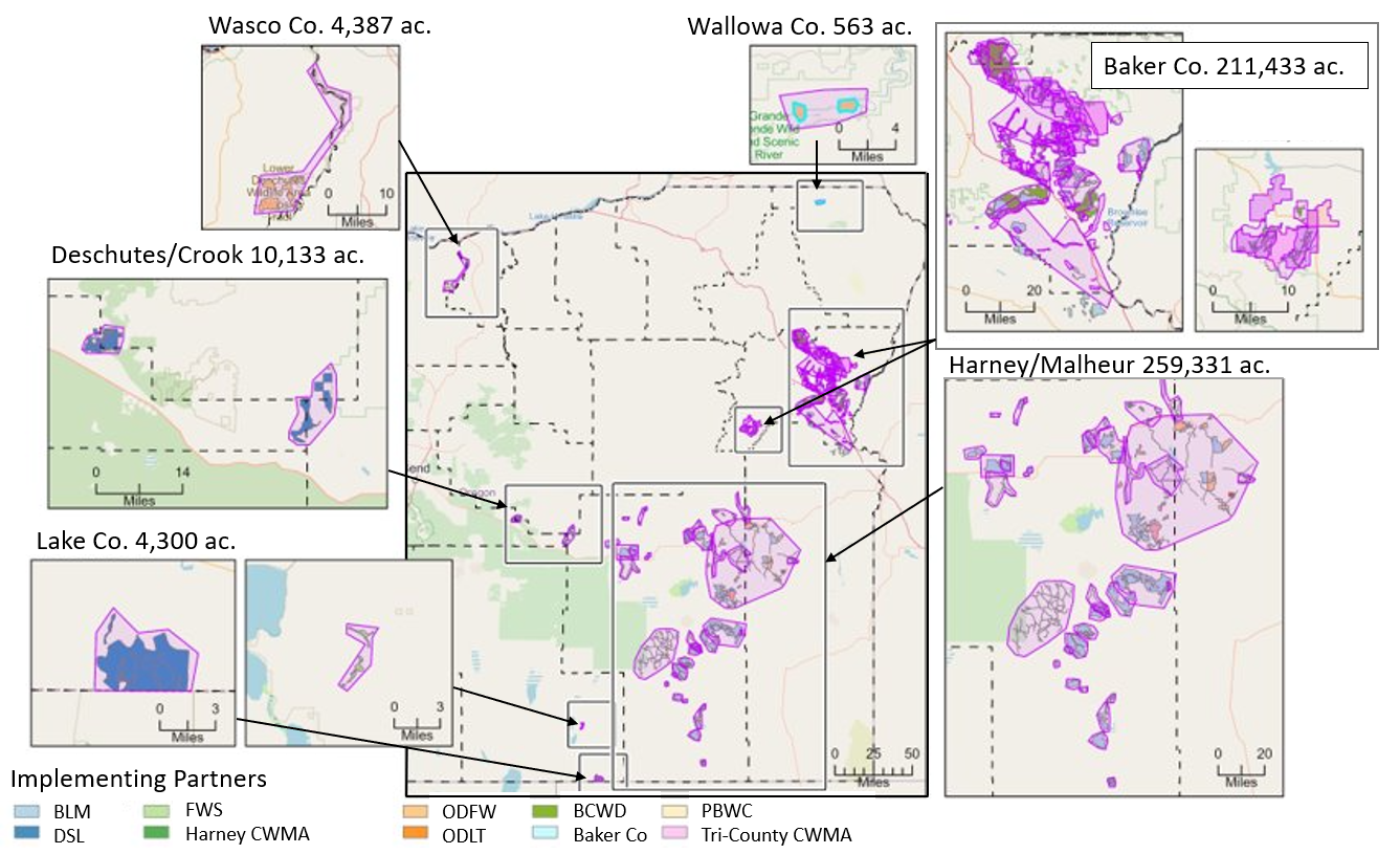
ORMP partners monitor large-scale restoration treatments throughout eastern Oregon using a standardized, repeatable, multi-scaled, and streamlined protocol.

Acres reflect treatments with ORMP plots that will be monitored in 2026
Analyzing and summarizing treatment results on demand using a customizable web-based platform
ORMP uses the best available science
How do we harness practitioners’ experience to inform future restoration treatments and adaptive management?
Land managers need the best strategies to guide our restoration efforts in eastern Oregon.
However, often our best available science occurs at small scales (research plots) and the results can be hard to access because they are buried in scientific journals.
While published, peer-reviewed studies are scientifically sound, because they use intensive monitoring methods and a standardize, repeatable study design, it can be unclear if the results are applicable at real-world scales.
Published, peer-reviewed research
Landscape scale restoration

How does ORMP work?
Step 1: Submit maps of the treatment polygons
The project manager provides a shapefile and pertinent details about the treatment type and implementation.
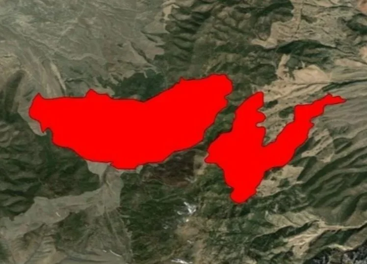
Example Seeding Treatment Area
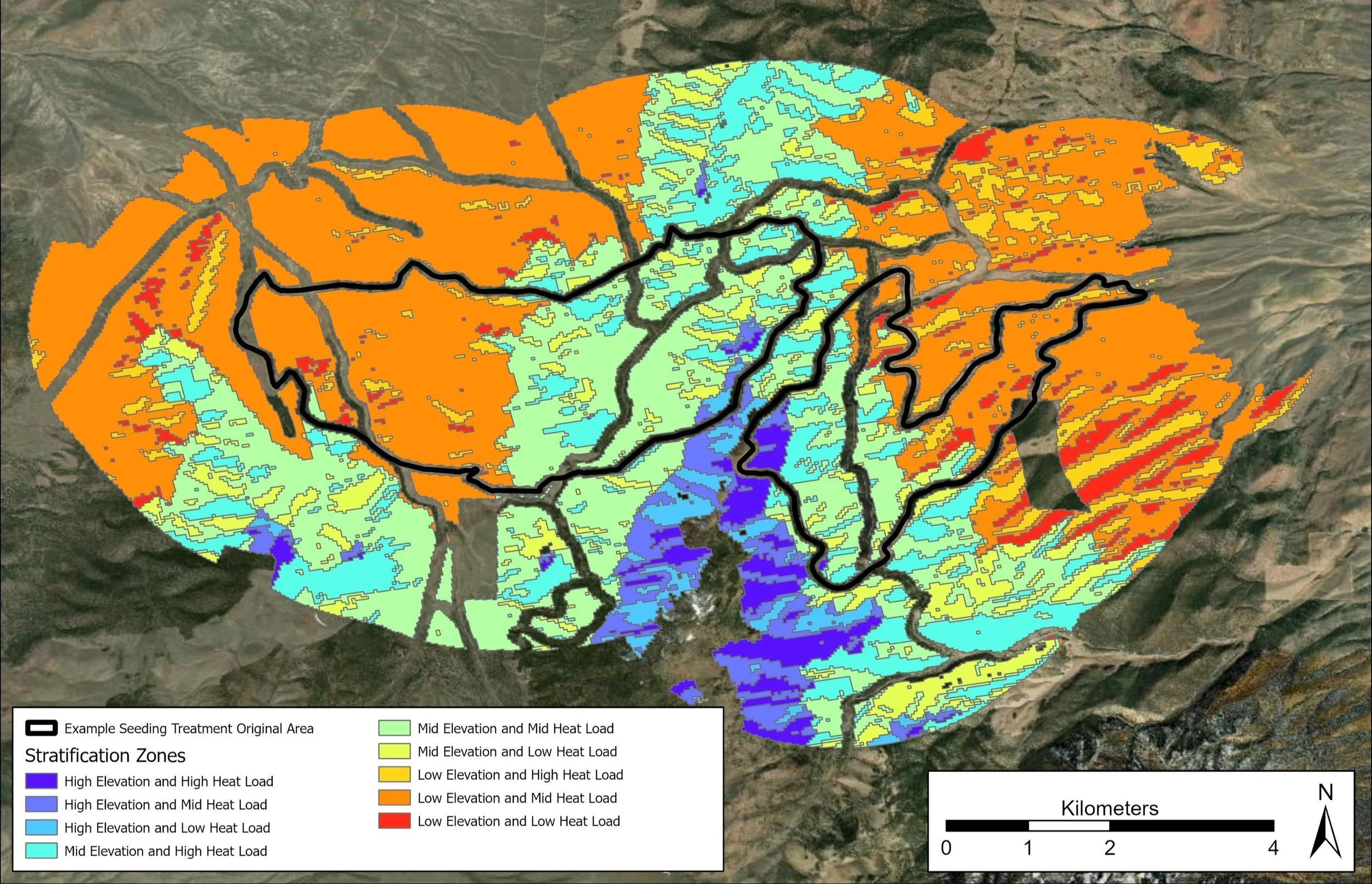
Step 2: Heatload Stratification
Control (reference) areas are identified within a zone surrounding the treatment area. Both the control and treatment areas are stratified according to elevation and heatload (a metric that incorporates aspect and solar radiation). Heatload and elevation often vary across a treatment, accounting for differences in existing vegetation pre-treatment and potentially variable effectiveness of the restoration treatment.
Step 3: Monitoring locations are generated
Monitoring plots are randomly placed within treatment polygons and adjacent control (reference areas). Points are placed as equally across the elevation and heat load strata as possible and backup points are also generated in case “preferred” points cannot be accessed or are unrepresentative.

Step 4: Field data collection
Monitoring crews collect data (where permitted) using Survey123 and Field Maps. Ideally data are collected prior to and after treatment implementation. The post-treatment monitoring schedule depends on treatment type and land management goals.
Crews assess 13-m radius plots using a rapid ocular assessment of key functional vegetation groups and assign a threat-based ecostate representing the general condition. One plot per treatment is randomly selected and additionally monitored using a line-point intercept method (identical to methods used by the Bureau of Land Management).


Step 5: Data Sync
Back in the office or within cell service, crews “sync” their data. Data is stored on ArcGIS Online.
Step 6: Data QA/QC
Field crews review data and correct errors. Data area also reviewed by USGS using statistical software.
Step 7: Analyses, summaries and reports (under development)
Because data are collected in a standardized way, automated and dynamic analyses can be easily performed. A user-friendly web-based tool is under development for end users to readily visualize and interpret data.
Accomplishments to date:
Since 2022 through the 2025 season, partners across Oregon have collected information that contributes to a broader understanding of treatment outcomes for 359 treatments that total to 391,643 acres of treatment effort occurring on private, Oregon Department of State Lands, Oregon Department of Fish and Wildlife’s wildlife areas and Bureau of Land Management lands. Over 1,000 monitoring locations were surveyed.
How can I get involved?
If you are interested in monitoring your restoration projects using ORMP, please contact Jackie Cupples.
For additional information contact:
Jacqueline Cupples, jacqueline_cupples@fws.gov
David Pilliod, dpilliod@usgs.gov
Project partners:
ORMP is made possible with the support and interest of many federal, state, and local partners. Funding provided from U.S. Fish and Wildlife Bipartisan Infrastructure funds, U.S. Geological Survey, and Oregon Watershed Enhancement Board.
