

Prioritizing Mesic and Riparian Restoration across Large Rangeland Landscapes
Photo: Spring fed stream in the Trout Creek Mountains of Oregon.
Overview
Riparian areas are important everywhere, but are especially vital in rangelands as a rare source of water in an arid environment, providing critical and limiting habitat for many species. This workflow highlights a step-by-step process using a combination of remotely sensed data layers and field-based assessment for prioritizing mesic and riparian areas in rangelands. This workflow prioritizes areas for mesic protection and restoration based primarily on ecological importance and climate resilience.
A workflow for prioritizing mesic resources
Use our step-by-step workflow combining remotely sensed data layers and field-based assessment for prioritizing mesic and riparian areas in rangelands!
If I’m a beginner, where do I start?
Riparian systems are complex. For a basic understanding of working in flowing water (lotic) systems, the Threat-Based Land Management for Creeks, Streams and Rivers website has basic information to help you get started.

VIEW THE FULL WORK FLOW
Work Flow Summary
Step 1:
Initial prioritization based on broad landscape values
If you’re starting in a very large landscape, narrow it down based on ecological integrity, species of wildlife concern, or other important values. At the end of this step you will have a focal polygon that focuses your efforts based on ecological integrity and other landscape values.
Step 2:
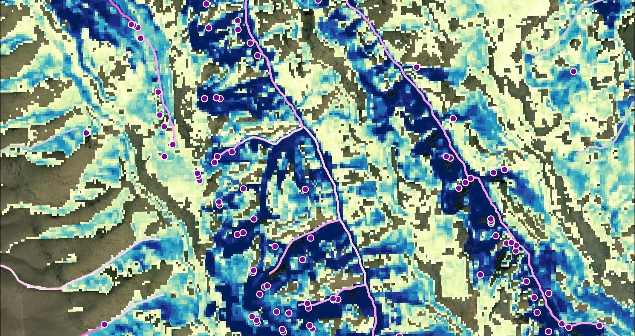
Mesic area prioritization based on remote sensing
This workflow prioritizes areas with higher expected climate resilience based on areas with reliable and persistent water into the late summer. Three new datasets are now available within the SageCon Landscape Planning Tool to help identify the areas that are most likely to remain climate resilient into the future. An accompanying decision tree helps prioritize spring and/or stream sites where you may want to conduct field-based assessments to gather further information. Check out these datasets available in the Water folder:
Oregon Springs (Groundwater Dependent Ecosystems) is the most comprehensive statewide dataset of springs in Oregon
Oregon Streams (Groundwater Dependent Ecosystems) depicts the degree of confidence that a stream reach may be groundwater-dependent for all streams in Oregon
Late Season Mesic Productivity provides a fine-scale look at areas with consistent late summer production
Access the data layers in the Landscape Planning Tool
See the data layers in the Water folder
Step 3:
Field-based assessment in selected areas
Field assessment is a key component to start prioritizing areas for potential management actions. We present multiple methods for field assessment at selected sites. Field assessment notes will provide critical information on current conditions, verify or correct the resiliency categorization based on remotely sensed maps in step 2, and help determine potential management actions and degree of investment that may be needed to restore a site.
Step 4:
Prioritization of areas for management
Putting it all together, we provide a simple table to combine information from steps 1-3 to prioritize areas that combine high importance (step 1), high resiliency (step 2) and good condition (step 3) where efforts are most likely to succeed. Priority designation for all spring and/or stream sites based on expected climate resilience, condition, and degree of investment needed.

VIEW THE FULL WORK FLOW

This workflow was developed by the Rangeland Sustainability Program at the Institute for Natural Resources.

Photo Credit: Jessie Griffen
This workflow is based on a process conducted by graduate student Hayley Kolding of the University of Vermont, The Nature Conservancy, and Oregon Desert Land Trust at Trout Creek Ranch in Harney County, Oregon, highlighted in an April 2024 webinar.