Hot New Tech: Empowering SageCon partners to use science, technology and tools to improve management outcomes on the ground
Summer 2025
Synthesizing and Integrating Data to Tell a Story
In a world with an increasing amount of data, many of us struggle to turn the large volumes of data from maps, plots, photos, field observations and other sources into meaningful and actionable information. The Institute for Natural Resources compiled a suite of case studies integrating multiple types of data, ranging from simple “pasture snapshots” to tracking treatment outcomes with a combination of map and plot data, to a simple but effective workflow to guide efficient field data collection. The examples provide a variety of formats and visualizations, which are all generated using easy-to-use tools such as web mapping platforms and spreadsheets without the need for advanced techniques or analyses. Check out the examples and see if any of them spark ideas for how to simply but effectively summarize your data.
Monitoring Data Added to SageCon Landscape Planning Tool
The list of updates to the SageCon Landscape Planning Tool continues with the addition of data from thousands of monitoring plots from the BLM’s Assessment Inventory and Monitoring (AIM) program. Detailed vegetation data has been collected on BLM lands throughout southeastern Oregon since 2016, and the rich suite of indicators in the dataset can complement the maps in the tool; for instance, helping to understand the composition of grasses beyond broad functional groups. The AIM data can be found just above the ecostate map in the layer list - activate the data layer, zoom in, and click on an AIM point to get a summary of the composition of the vegetation in each year a plot was sampled.


Spring 2025
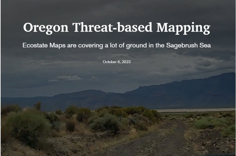
Threat- Based Ecostate Map Update
In the summer of 2024, the Institute for Natural Resources updated Threat Based Ecostate Maps to version 4, and in spring 2025 we added the 2022-2024 time slice. Ecostate maps provide a generalized snapshot of rangeland condition and trend based on ecosystem-level threats from invasive annual grasses, wildfire, and conifer encroachment. Following an accuracy assessment using field-based data, we made some small changes to the maps in version 4, outlined below. It is important to note that version 4 will not be compatible or comparable to earlier versions due to the ruleset changes – be sure to re-download or re-summarize ecostate maps if you have used ecostate maps prior to July 2024.
Ecostate maps can still be viewed and summarized over time in the SageCon Landscape Planning Tool, within Oregon and across the sagebrush biome. See the ecostate landing page and ecostate storymap for more information.

Summary of changes in ecostate map v4:
Ecostate maps are now available across the sagebrush biome for all available years (1989-2024), and can be analyzed using the ecostate summarization tool within the SageCon Landscape Planning Tool. Ecostate maps were developed to capture sagebrush systems in southeastern Oregon; use caution when applying these maps outside of the northern Great Basin and outside of areas of current or historic sagebrush steppe.
Shrub cover threshold increase from 10% to 12% for all shrubland categories (A, A-C, and C) to improve overall accuracy and account for recent overestimation of shrub cover in the underlying datasets. As always, recognize that thresholds used in these maps are imperfect across the highly variable sagebrush ecosystem.
Slightly different color scheme to better convey the relationships between ecostates, in particular changing state B-D to a color more similar to B. An alternative visualization option (in a layer file available upon request) may be more conducive for users with common types of colorblindness.
Juniper: low-mid cover & Juniper: high cover renamed to Trees: low-mid cover & Trees: high cover to reflect the fact that these ecostates cover all areas with trees, not just juniper. Also note that a new Conifer Threat Map is available on the Landscape Planning Tool to complement the ecostate map with more information in areas with conifer encroachment.
Forests and woodlands are no longer masked out. Instead, they will be included in the Trees: high cover category. Areas excluded from mapping are urban, agriculture, and barren areas.
Simplified attributes table for ease of use.
Summer 2024
Mesic Prioritization
Mesic and riparian ecosystems in sagebrush country provide critical moisture in otherwise parched dryland environments, and mesic restoration is a focus for many partners. In April 2024, SageCon hosted a webinar: Mesic prioritization at Trout Creek Ranch: tools for prioritizing mesic restoration across large landscapes. The webinar featured tools and a process for using a combination of remote sensing and field-based data to identify mesic restoration opportunities based on climate resilience and riparian condition at Trout Creek Ranch in Harney County.
Following the workshop, we worked with our team to produce a simple workflow for prioritizing mesic areas that can be used in other rangeland landscapes, with step-by-step instructions to follow the process and access to all data layers through the SageCon Landscape Planning Tool. In particular, note that a new Late Season Productivity (NDVI) layer has been added to the tool, providing the finest-scale map of mesic features in Oregon’s rangelands to date, courtesy of the team at Climate Engine.
For more information about stream assessment see Threat-based Management for Creeks, Streams and Rivers: A Manager’s Guide for Understanding and Managing Flowing Waters in Sagebrush Ecosystems of the Pacific Northwest

Winter 2024
Oregon Rangeland Monitoring Program
In an era where rangeland restoration activities are occurring at an unprecedented rate, the Oregon Rangeland Monitoring Program (ORMP) is a collaborative effort to measure and communicate the outcomes of restoration treatments across public and private lands.
Using the skillsets of a diverse stakeholder and expert group, ORMP includes guidance on where to place monitoring plots, a rapid and standardized data collection protocol and mobile platform, and a summary of treatment outcomes in a web-based dashboard. Find out more on the ORMP website.

Fall 2023
New StoryMap Brings Ecostate Maps to Life
The Institute for Natural Resources helps bring threat-based ecostate maps to life with a StoryMap explaining how the maps are built, how they are used, and how to access data.
Even better, you can now download a georeferenced PDF of the most recent ecostate map for counties in southeastern Oregon - allowing you to display the ecostate map on your mobile device relative to your location as you move through the range. See the Ecostate Data Access section on our ecostate mapping homepage. Let us know how well the maps hold up in your neck of the range!
SageCon Technical Trainings and Workshops
Fall 2023
SageCon wants to keep you updated on the most impactful and actionable science and technology to guide your work. We periodically host technical trainings and events - keep up to date on the haps from our SageCon events page.
In 2024, the Institute for Natural Resources, OSU extension, and Agricultural Research Service started a series of Threat-Based Strategic Conservation workshops with local collaborative groups in Oregon, with the goal of helping our partners develop their own science-informed but locally-derived spatial strategy to defend and grow the core.


Featured Tool:
SageCon Landscape Planning Tool
The SageCon Landscape Planning Tool was developed by the Rangeland Sustainability Program at the Institute for Natural Resources to help SageCon partners conduct coordinated planning across rangelands in eastern Oregon. The tool allows users to view datasets through an interactive map, download data, and summarize ecostate maps through the Ecostate Summarization Tool. It currently includes dozens of curated datasets, with updates in early 2025:
Conservation and restoration actions taken on public land, including efforts to control invasive species, reduce fuels, and others
Wildlife habitat datasets for sage-grouse and other species
Previous and current fire perimeters and wildfire risk
Water-related datasets, including springs, streams, and late-season mesic productivity
Rangeland vegetation maps, including ecostate maps, vegetation cover of major plant functional groups, and other synthesis maps
Landscape characteristics such as a elevation-heatload index
Management boundaries and land ownership for reference
Summer 2024 with UPDATE in Spring 2025
Spring 2023 with UPDATE in Spring 2025
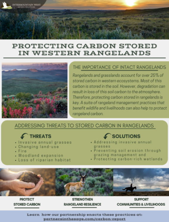
Storing Carbon in Sagebrush Rangelands
Natural and working landscapes across the globe store large amounts of carbon, and there is interest in how to secure carbon in soils and vegetation across the vast expanses of sagebrush steppe in southeastern Oregon and across the Great Basin. The Institute for Natural Resources and partners at the US Geological Survey and Agricultural Research Service convened a working group and produced the storymap Conserving Carbon in the Sagebrush Steppe outlining our current knowledge about carbon in sagebrush country, how various threats and management actions impact carbon, and how to think about carbon in the arid sagebrush landscape. Here are our take-home messages:
Focus on carbon security (retaining existing carbon) rather than carbon sequestration to maximize carbon storage
Managing for ecological integrity is managing for carbon - actions that promote healthy sagebrush steppe also help to secure carbon
Maintain a long-term perspective, because carbon cannot be gained quickly in the sagebrush ecosystem
This work follows a previous science synthesis featured in this newsleter from our partners at the Intermountain West Joint Venture, captured in their report Storing Carbon on Sagebrush Rangelands. Check out IWJV’s Partners in the Sage website for more content relevant to western rangeland conservation.